Wetlands include a wide range of habitats with variable wetness. At the simplest levels, wetlands can be divided into nonvegetated and vegetated wetlands. Nonvegetated wetlands are characterized by open shallow water (less than 6 feet deep) or by alternatively flooded and exposed bare substrates like mudflats, sand bars, ocean beaches, cobble-gravel bars and flats, and rock outcrops. Wetlands colonized by macroscopic plants (visible to the naked eye) are called vegetated wetlands. They can be further defined by the general life form of their vegetation and further still by their dominant vegetation, such as water lily beds, cattail marshes, red maple swamps, cottonwood floodplain forests, leatherleaf bogs, and sedge meadows. The U.S. Fish and Wildlife Service has developed a wetland classificiation system for mapping wetlands across the county (see last paragraph of this section for brief discussion).
Generally speaking from a hydrologic standpoint, wetlands can be separated into two basic categories: 1) tidal wetlands and 2) nontidal wetlands. Tidal wetlands occur along the coast where tidal flooding occurs, whereas nontidal wetlands are beyond the reach of the tides. Water in tidal wetlands comes mainly from ocean-driven tides, while precipitation, river overflow, and groundwater are major sources of water for nontidal wetlands.
Tidal wetlands
include nonvegetated mudflats exposed at low tide, rocky shores (with or without algae), salt and brackish marshes (tidally flooded grasslands), and mangorve swamps (salty shrub thickets and forests in the tropics). These areas are periodically flooded by tides, some every day and many less often (some only by storm tides). They occur along the Atlantic, Pacific, Arctic, and Gulf of Mexico coastlines. Tidal wetlands are most extensive in the southeastern U.S. where they have formed behind barrier islands and along coastal rivers. Tidal wetlands in saline and brackish areas are called "estuarine wetlands" as they are part of the estuary where salt water mixes with fresh water running off the land via rivers.
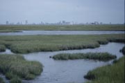 |
Figure 8. Atlantic coast salt marsh. |
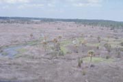 |
Figure 9. Aerial view of black needle rush-dominated wetland in the Southeast. |
Nontidal wetlands
are wetlands of America's interior, although they also occur in the U.S. Coastal Zone in areas beyond the reach of the tides. They include: 1) the shallow water zone of lakes, rivers, and ponds, 2) aquatic beds formed by water lilies and other floating-leaved or free-floating plants, 2) emergent wetlands dominated by herbaceous plants (including grasses, sedges, and flowering herbs), 3) shrub wetlands characterized by brushy growth (woody plants typically with multiple trunks and not growing above 20 feet in height) and 4) wooded swamps or forested wetlands dominated by trees of various sorts. Most nontidal wetlands are called "palustrine wetlands" according to the U.S. Fish and Wildlife Service's wetland classification system. They include freshwater wetlands and inland saline wetlands (alkaline wetlands) in arid and semiarid regions.
Aquatic beds are common in protected shallow water. Here rooted aquatics like water lilies, pond lilies, pondwweds, and water shield grow with floating plants such as bladderworts, coontail, and duckweeds. These are the easiest wetlands to recognize.
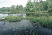 |
Figure 10. Emergent wetland and aquatic bed in freshwater pond. |
Emergent wetlands
include a number of types. Marshes occur in shallow water or
in areas subjected to extended periods of flooding. COmmon marsh
plants include cattails, bulrushes, bur-reeds, and wild rice.
Fens are sedge-dominated emergent wetlands in northern regions
such as Minnesota, Michigan, New York, and New England. They
tend to have significant groundwater contributions that provide
them with more nutrients than other wetlands in these regions,
and may be called "minerotrophic". Wet meadows are
like fens but found across the country, especially in agricultural
areas. Many wet meadows were formerly forested wetlands that
were cleared for pastures or cropland, and are maintained in
an open condition. Common plants of wet meadows include various
sedges (such as tussock sedge in the Northeastern U.S.), rushes,
grasses like bluejoint and reed canary grass, and flowering herbaceous
plants including Joe-Pye-weeds, thoroughworts, goldenrods, asters,
and many others. Some wet meadows possess very diverse plant
communities, although many are virtually pure stands of grasses
or sedges. Pothole wetlands are typical emergent wetland type
in the Prairie region of the Upper Midwest. These wetlands are
marshes and wet meadows growing in a semiarid region. Playas
are western marshes in shallow depressions in the Southwest.
Wetlands in the Prairies and the Southwest are often subjected
to prolonged droughts which affects their vegetation.
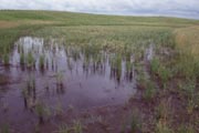 |
Figure 11. North Dakota prairie pothole wetland. |
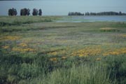 |
Figure 12. California vernal pool (emergent) wetland. |
Shrub wetlands
(or scrub-shrub wetlands) come in many types. In northern regions or higher elevatations (mountainous areas), shrub bogs and alder swamps are common. THe bogs are nutrient-poor, acidic wetlands ("oligotrophic"). Thick organic (peat) deposits up to 50 feet deep or more form in bogs. Other shrub swamps tend to develop on mineral soils (waterlogged silts, loams or clays) Some other dominant species of shrub swamps are willows, dogwoods, arrowwoods, highbush blueberries, buttonbush, swammp rose, titi (in the South), and saplings of trees such as red maple.
Numerous types of forested wetlands also exist. Regional difference in climate and local differences in hydrology, soils, and nutrients create a wide range of types. Some common types are red maple swamps and black spruce forested bogs in the North, Atlantic white cedar swamps along the Atlantic Coastal Plain, floodplain wetlands with silver maple, cottonwoods, sycamores, and other species in broad river valleys, deep swamps in the South (cypress-gum swamps flooded for long periods), swamps dominated by evergreen trees (hemlocks, pines, and balsam fir), and tropical rainforests of broad-leaved evergreen species. A rich understory of shrubs, ferns, and other herbs may be present in the more minerotrophic (nutrient-rich) swamp forest. Forested wetlands form on organic soils (peats and mucks), hydric loamy and clayey soils, and hydric sandy soils.
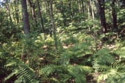 |
Figure 13. Red maple swamps are common in the Northeast. |
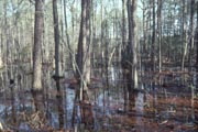 |
Figure 14. Loblolly pine wetlands (so-called "winter wet woods" or "wet flatwoods") are typical of the Southeastern Coastal Plain. |
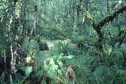 |
Figure 15. Florida hardwood swamp gives a feeling of a tropical rainforest. |
A fairly comprehensive listing of U.S. wetland plant communities is given in "Wetland Indicators: A Guide to Wetland Identification, Delineation, Classification, and Mapping" (R. Tiner, 1999) published by Lewis Publishers (Boca Raton, Florida) and available for purchase from IWEER. It contains a chapter on U.S. wetlands with 21 pages of tables detailing wetland plant communities across the country and provides listings of major reference works on individual wetland types.
The U.S. Fish and Wildlife Service has developed a wetland classification system for mapping wetlands in the United States: "Classification of Wetlands and Deepwater Habitats of the United States." Wetlands and deepwater habitats are first divided into five ecological systems: 1) marine (open ocean and its associated shoreline), 2) estuarine (estuaries where mixing of salt and fresh water occur), 3) riverine (channels of rivers and streams), 4) lacustrine (lakes, reservoirs, and deep ponds), and 5) palustrine (mostly freshwater wetlands and shallow ponds plus inland saline wetlands).
Most of the nation's wetlands are palustrine wetlands. Wetlands are associated with the intertidal subsystem of the marine and estuarine systems, the littoral (shallow water zone) of the lacustrine, the shallows of riverine systems, and the entire palustrine system. At the class level in the classification system, wetlands are separated by predominant life form of the vegetation (where more than 30% of the area is vegetated) or by the predominant substrate for other wetlands. Vegetated classes include aquatic bed, emergent wetland, scrub-shrub wetland, forested wetland, and moss-lichen wetland. Nonvegetated classes include rocky shore, unconsolidated shore (e.g., mudflat and sandy beach), streambed, rock bottom, and unconsolidated bottom. Wetlands may be further described by vegetation or substrate subclasses and by various modifiers including water regime (hydrology), water chemistry (pH and salinity/halinity), soil (organic or mineral), and special modifiers (describe human actions - partly drained, diked/impounded, excavated, and artificial - plus beaver activity).
|